
The Arran Corbetts
At 3.45am on Thursday 20th September 2007, I set off on what turned out to be a six-hour car journey, from home to Claonaig, to catch the 10:10 ferry across to Lochranza, Arran. Unfortunately, the cloud was quite low.
Looking across to Arran from Claonaig:

On board the Claonaig Ferry:

Following a half-hour trip on the Calmac ferry, I arrived at Lochranza and then continued on driving through to Cladach, where I parked beside the Isle of Arran brewery.
Hill: Goatfell
Date: Thursday 20th September 2007
Company: Just myself
Time: 2Hrs 30Mins
Click here to see a map of the route undertaken
After passing the Wineport, I continued along a good track through a wood with lots of ferns and brambles at the track-side. The path to Goatfell from this starting point is possibly one of the best-constructed paths to be found in the Scottish hills.
Looking down lower path of Goatfell:

Goatfell:

Before long, I was passing tourist after tourist, puffing and panting their way up this tourist-attraction of a hill.
Having paid no attention to the map during the ascent, I was surprised to find that I had ascended so quickly reaching the summit cairn and toposcope within circa 90 minutes of setting off from the car.
Ascending Goatfell:

Summit of Goatfell:

Goatfell toposcope:

Fortunately, the mist cleared for a few minutes while sitting at the summit of Goatfell providing views across to Cir Mhor and the A’Chir ridge and also out towards North Goatfell.
After a bite to eat, I returned to the car via the same route making the descent in around 60 minutes.
View from summit of Goatfell:

Looking back to Goatfell:

A nice and easy first day on Arran.
Hills: Beinn Tarsuinn, Caisteal Abhail, Cir Mhor
Date: Friday 21st September 2007
Company: Just myself
After spending an enjoyable night in the Lochranza Youth Hostel, I set off around 8.00am to park just before the bridge at the beginning of the road/track leading into Glen Rosa.
Click here to see a map of the route undertaken
I followed the good track, past the campsite (which is really just a field), until reaching the bridge over the Garbh Allt.
Looking up Garbh Allt from Glen Rosa:

After crossing this bridge I immediately began the ascent, alongside the Garbh Allt, until reaching a deer-fence with bits of heather tied to it for what seemed to be its entire length.
Looking back down Glen Rosa:

Looking across to Goatfell from Glen Rosa:
Looking up Garbh Allt:
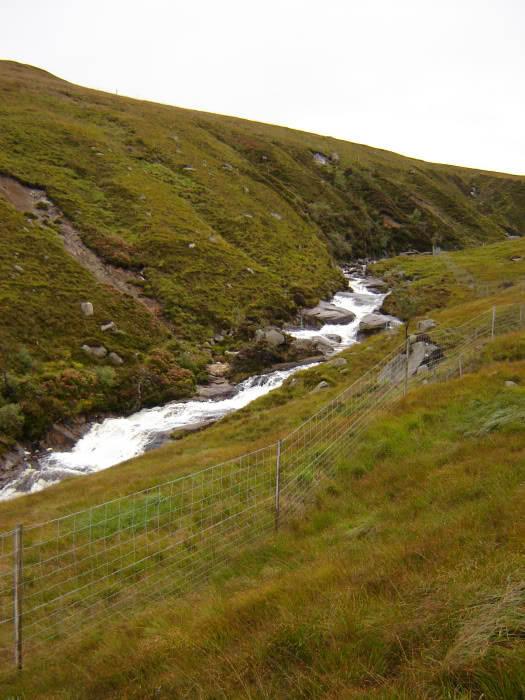
Owing to the burn being in spate, I was unable to cross at the normal crossing point.
Burn I couldn’t cross:

A bit further upstream, I crossed the burn before following the path up Beinn Nuis.
Looking back from Beinn Nuis to boggy area:

Well-constructed path up Beinn Nuis:

Summit of Beinn Nuis:

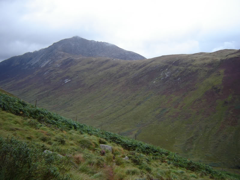
On reaching the top of Beinn Nuis, I continued on, in low cloud, to eventually reach the summit of the first Corbett Beinn Tarsuinn, passing a rather strange rock ”face” en-route known as the Old man of Tarsuinn.
Old man of Tarsuinn:

Owing to the low-cloud, and lack of a summit cairn, I decided to get the GPS out to confirm I was actually at the summit.
From the summit of Beinn Tarsuinn, after a few bits of easy down-scrambling, I reached the starting point of the A’Chir ridge.
Given I could barely see twenty feet in front of me because of low-cloud, I decided to take the by-pass path below the A’Chir ridge – this is basically a walk which avoids all difficulties.
Looking up towards A’Chir from bypass:

Looking back to Beinn Tarsuinn:

After several hundred metres of skirting the ridge I began the ascent to re-gain the ridge between A’Chir and Cir Mhor. At this point I had to decide whether to tackle Cir Mhor or Caisteal Abhail first. I opted for Caisteal Abhail.
The A’Chir ridge:

Cir Mhor:

I took a path skirting below the summit of Cir Mhor to reach the bealach between Cir Mhor and Caisteal Abhail and then continued on up easy grassy slopes up Caisteal Abhail. I passed the source of a spring en-route marked by a large cairn.
Caisteal Abhail:

Spring on Caisteal Abhail:

As I reached what I thought to be the summit of Caisteal Abhail, I was confronted in the mist by a rock-face. My first thoughts were to climb this rockface, my second thoughts were ‘No, this is a rock climb there must be an easier way up.” My second thoughts were correct, a path round the side of this rock-face led to a very easy ascent to the summit of Caisteal Abhail.
View from summit of Caisteal Abhail:

View from summit of Caisteal Abhail:

After a bite to eat, I returned via the same route to the bealach between Caisteal Abhail and Cir Mhor but this time began the ascent of Cir Mhor. Fortunately, this ascent was far easier than it looks. I followed a path for most of the way and reached the summit of Cir Mhor encountering no difficulties.
Cir Mhor:

Looking back to Caisteal Abhail:

The Witch's Step (zoomed):

Cir Mhor:

View from summit of Cir Mhor:

The descent from Cir Mhor was also very easy as I headed first down grassy slopes and then down an incredibly good path into Fionn Choire. Great views across to Sou’wester Slabs and other rock climbs from this path.
Close up of Rosa Pinnacle:

The walk back out along Glen Rosa seemed to take forever after what had been quite a long day with a considerable amount of ascent and descent. Was glad to eventually reach the car.
I returned home the following day leaving behind almost perfect weather - just my luck!
View from Lochranza:

Ferry Entrance to Lochranza:

Looking back to Lochranza from Ferry:

Looking forward to a return to Arran.