
Hills: Souther Fell, Blencathra, Mungrisdale Common, Bannerdale Crags and Bowscale Fell
Date: 11th July 2013
Company: Just myself
Distance: 18.1km, Ascent: 1030m
Time: 5Hrs 50Mins
Yesterday lunchtime I decided that I fancied a few days walking in the Lake District. I booked some last-minute accommodation via Late Rooms and headed-off a few hours later after finishing work. A real last-minute plan
Circa six hours later, I arrived in the North Lakes and spent last night in a nice small hotel overlooking Bassenthwaite Lake.
This morning, I decided to ascend Blencathra. A quick look at the map showed five Wainwrights that could potentially be linked together in a circuit. Even better, this route would allow an ascent of Blencathra via Sharp Edge.
I drove to Mungrisdale and parked on a grassy verge a few hundred metres from the Mill Inn. On leaving the car, just after 09:00, it was already 20C
Click here to see a map of the route undertaken
From the car, I made my way along to the Mill Inn.
The Mill Inn, Mungrisdale:

While standing at the Mill Inn, I spotted two birds directly above me that I think were possibly Ospreys. (There was a sign a few miles back advising of Ospreys on Bassenthwaite Lake)
Osprey?:

Osprey?:

From the Inn, I double-backed a short distance along the upper road and climbed over a gate to enter a field. Once in the field, I made my way across to the corner of the field where I climbed over a fence to reach the start of the South-West ridge. On the other side of the fence was a sign advising, "There is not a Public Footpath through this Field. Please Keep Out." I'm guessing therefore that you are not supposed to walk through this field
Initial ascent of South-West ridge of Souther Fell:

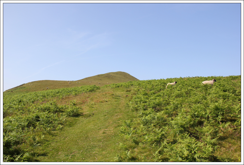
Once on the ridge, I followed a narrow path through the bracken which widened a few hundred metres further on.
Looking back to the Mill Inn, Mungrisdale:

Once onto the wide track, the ascent of Souther Fell was straight-forward apart from the incredible heat.
Ascending Souther Fell:
Looking across to Blencathra and Bannerdale Crags from summit of Souther Fell:

From the summit of Souther Fell, I traversed the hill taking a wee detour to visit a large cairn.
Large cairn on Souther Fell:

While descending from Souther Fell, I got my first real view of Sharp Edge
Looking across to Sharp Edge from Souther Fell (zoom):

After descending circa 100m, I reached a good track leading to Scales Tarn.
On the track below Scales Fell leading to Scales Tarn:

Looking towards Sharp Edge:

En-route to Sharp Edge, my mind was pretty-much focused on Sharp Edge, that is until I spotted a bikini-clad babe sitting at the edge of Scales Tarn. Not a sight you see often on the hills!
Sharp Edge (zoom):

From Scales Tarn, I made my way up to the start of Sharp Edge.
Looking back to Scales Tarn and across to easy route to summit of Blencathra:

The initial scrambling can all be avoided via bypass paths. However, I didn’t see the point in taking the scrambling route, and then avoiding the scrambling, so I stuck to the crest of the ridge.
The start of Sharp Edge:
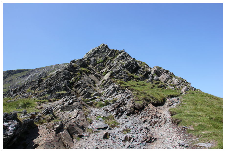
Initial scrambling on Sharp Edge:

I began scrambling with my large camera case strapped to my chest but soon ended up putting it into my rucksack as it was restricting the view of my feet - it is good to see where you are putting your feet when scrambling. As a result, I had to stop several times on Sharp Edge to get the camera out of the rucksack. I was in no hurry.
Looking back to Scales Tarn from Sharp Edge:

Sticking to the crest, the ridge narrows:

Sharp Edge is a really nice Grade I scramble. The rock is however fairly polished in places – I wouldn’t fancy doing this ridge when wet.
On Sharp Edge:

Looking back to another scrambler on Sharp Edge:

Looking back to the most exposed section of Sharp Edge:

Final ascent of Sharp Edge:

Follow the gully:

Looking back along Sharp Edge from the top:

Looking back along Sharp Edge from the top:

On reaching the top of Sharp Edge, I got the camera back out and proceeded to the summit of Blencathra. I was surprised to see so few people at the summit of this excellent hill.
Trig survey marker at the summit of Blencathra:

Looking towards Knowe Crags from the summit of Blencathra:

From the summit of Blencathra, I made my way across to the 845m top and then after a short descent, made my way across to Mungrisdale Common.
Heading back towards the 845m top:

A cross:

While Blencathra is an outstanding hill, Mungrisdale Common isn’t in my opinion “a hill”. I’m not sure why Wainwright decided to make Mungrisdale Common a Wainwright. According to the Database of British Hills it only has a drop of 2m !!!
Heading out to Mungrisdale Common:

As I walked across to Mungrisdale Common, I ended up covered in hundreds of midge. I found this really surprising given it was sunny and very hot. Normally the wee bandits don’t like the sun.
Looking towards Skiddaw from the “summit” of Mungrisdale Common:

I didn’t spend any length of time at Mungrisdale Common before making my way back and on to the next peak of the day, Bannerdale Crags.
Looking back to Blencathra:

Heading for Bannerdale Crags:

Sharp Edge from Bannerdale Crags (zoom):

Blencathra from the summit of Bannerdale Crags:

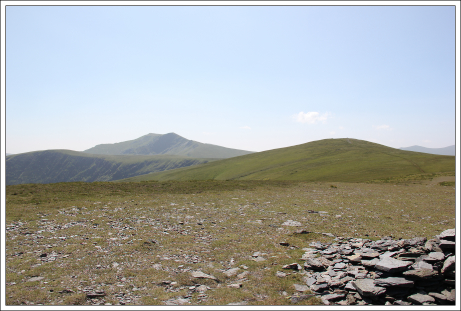
Looking towards Bowscale Fell from the summit of Bannerdale Crags:

From Bannerdale Crags, I skirted round the top of the crags before picking up the main path leading out to Bowscale Fell.
Bannerdale Crags:

Looking back to Bannerdale Crags:

Bowscale Fell:

By the time I reached the summit of Bowscale Fell, I was really feeling the heat and my water was almost finished. A quick check of the map confirmed that I had only circa 3km to go to get back to the starting point.
Looking back towards Blencathra from the summit of Bowscale Fell:

The descent from Bowscale Fell was mostly straight-forward following a nice, wide track.
Bannerdale Crags, Blencathra and Bowscale Fell from the North-East top of Bowscale Fell:
Descent towards Mungrisdale:

The final few hundred metres of descent was however fairly horrible – a steep path down through high bracken.
Steep descent through the bracken to Mungrisdale:

Always good to finish a walk at a pub
It was 27C in Mungrisdale - this probably explains why I was feeling the heat on the hill.
Really impressed with Blencathra. A cracking hill!