Hills: Arenig Fawr and Moel Llyfnant
Date: Monday 21st April 2014
Company: Just myself
Distance: 17.5km, Ascent: 1500m
Time: 5Hrs 30Mins
After a long day on the hills yesterday, it was my intention today to have an easy day ascending a couple of Sub2000ft Marilyns. However on waking this morning and looking out the window the weather looked outstanding! I therefore decided to make the most of the day by ascending a Welsh "Corbett" and a Welsh "Fiona".
I drove 22 miles from my base in Betws-y-Coed to park opposite a small quarry on the B4391 where there is room for dozens of cars on an area of waste ground (no charge for parking).
Click here to see a map of the route undertaken
From the car parking area, I walked almost exactly one mile along the B4391 to reach the start of the track leading to Llyn Arenig Fawr. I then followed the track towards the llyn.
Looking back towards Llyn Celyn from track to Llyn Arenig Fawr:

Arenig Fawr is a really nice hill. It was great to get away from the crowds of Northern Snowdonia and meet only a handful of other walkers throughout the day.
Arenig Fawr:

Llyn Arenig Fawr and Arenig Fawr panorama:

On reaching the small dam, I took a short detour to check out a very small building.
Llyn Arenig Fawr dam:

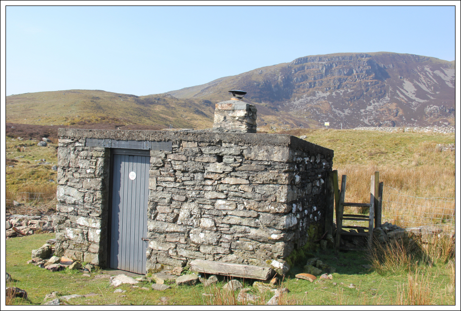
The building turned out to be Arenig Fawr bothy. This is the smallest bothy I have come across to date. Really nice though!
Arenig Fawr bothy:

Inside Arenig Fawr bothy:

After visiting the bothy, I crossed the dam and started the ascent towards Y Castell.
Crossing the Llyn Arenig Fawr dam:

Looking back to Llyn Arenig Fawr during ascent of Y Castell:

I took a short diversion from the track to visit the 684m top. I then returned to the track which I followed to the summit of Arenig Fawr.
Arenig Fawr from Y Castell:

Ascent of Arenig Fawr:

Looking towards the summit of Arenig Fawr:

The weather today was pretty good however it was very hazy. On a clear day, Arenig Fawr is meant to provide great views of Northern Snowdonia. Today, it was not possible to see that far.
Summit of Arenig Fawr:

At the summit, I stopped to read the memorial to the crew of a Flying Fortress that crashed into Arenig Fawr in 1943. Disappointing that the memorial has somehow sustained some damage.
Memorial at the summit of Arenig Fawr:

From the summit I next made my way across to the South top. En-route to the South top I met a man who warned me of a rocky section ahead with mild scrambling. Not sure what he was on about as there was no hands-on required just a few boulders to step over/around.
Looking back to Arenig Fawr from the South top:

Descent from South top of Arenig Fawr:

After descending from the South top, I took another small detour to visit the 712m top.
View from Arenig Fawr South top ridge (712m top):

Small llyns on South top ridge:

Panorama from South top ridge:

I think I possibly cut off a little bit early to make my way across to Moel Llyfnant. I did however end up following an ATV track to the col between Arenig Fawr and Moel Llyfnant.
Looking across to Moel Llyfnant:

Looking back to Arenig Fawr:

Having ascended circa 5000m in the past four days my legs were definitely feeling the steep ascent of Moel Llyfnant. I had to zig-zag my way up.
Approaching the summit of Moel Llyfnant:

I had to climb over a fence a short distance from the summit.
Looking across to Arenig Fawr from the summit of Moel Llyfnant:

Instead of returning to the col via the same route, as suggested in my guidebook, I decided to descend via the North ridge down to Amnodd-bwll.
Descending the North ridge of Moel Llyfnant:

Descending the North ridge of Moel Llyfnant towards Amnodd-bwll:

On reaching Amnodd-bwll I decided to take the road leading to Amnodd-wen.
Amnodd-bwll:

Amnodd-wen:

Until now this had been a fantastic walk on good terrain. However, the track beyond Amnodd-wen was fairly awful. It was good to eventually meet a ladder stile over a wall beyond which the terrain was much improved.
Arenig Fawr is a real gem of a hill.