
Hill: Bennachie
Date: Friday 14th January 2011
Company: Myself and Beinn
Time: 3 Hrs
Dog friendly: Yes
Of all the hills I have ascended, Bennachie is the one I have been up the most times.
I first visited Bennachie in 1980 on a primary school trip but we didn’t go to the top
Bennachie is an iconic hill in the North-East of Scotland.
Mither Tap is the most prominent top. It can be seen from many places across Aberdeenshire.
However, Oxencraig is the actual summit - circa 10m higher than Mither Tap.
Bennachie has four car parks – Rowantree car park, Bennachie Centre car park, Back o’Bennachie car park and Donview car park. Bennachie also has its own visitor centre.
If ascending Bennachie, it would be a real shame to only ascend the summit, Oxencraig.
Bennachie has a range of tops which can be tackled from various starting points and in various combinations. Bennachie also has a second Marilyn – Millstone hill.
Anyway, enough waffle
Click here to see a map of the route undertaken
I ascended Bennachie today starting at the Back o’Bennachie car park.
The start of the track is very clear as there is quite a bit of signage.
Ascent track from Back o’Bennachie Car Park:

I made my way up through the trees following the very good quality path.
Bennachie is a great family hill. During the ascent you pass benches and various stones with inscriptions including stepping stones and a large stone in the stream next to the path.
Stepping stones leading to a rock seat:

On exiting the forest, there are great views across the flat expanse of North Aberdeenshire. Several hills are visible during the ascent – Knock Hill, Tap O’Noth, the Buck O’Cabrach, Ben Rinnes, …
View from edge of forest:

View towards distant Knock hill:

It didn’t take long today to reach the top of Little Oxencraig, although the path was quite icy in places. All easily avoided – no need for Microspikes
Approaching top of Little Oxencraig:

View from top of Little Oxencraig:

After a brief stop at the top of Little Oxencraig I opted to head for Oxencraig next.
The Buck o’Cabrach and Tap O’Noth from Little Oxencraig (full zoom):

Looking towards Oxencraig:

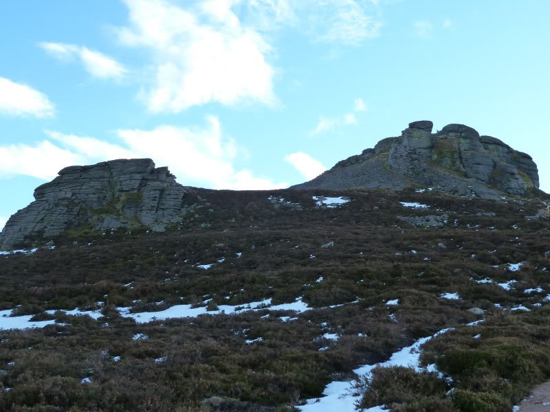
Craigshannoch and Mither Tap from path en-route to Oxencraig:

Little Oxencraig doesn’t actually feel like a separate top, it is really just a wee bump on the way to Oxencraig.
The walk from Little Oxencraig to Oxencraig doesn’t take long. There are good quality paths between all the tops.
The Forestry Commission would appear to have recently erected signage all over Bennachie. The signs are completely over-the-top – really big and obtrusive e.g. the one erected near the summit of Oxencraig can be seen from Craigshannoch and Mither Tap
I hope they see sense and remove the awful signs.
Small tors on Oxencraig:

Stone shelter at summit of Bennachie (Oxencraig):

At the summit, I stopped to view the toposcope and see what I could make out.
toposcope at summit of Bennachie (Oxencraig):

Mither Tap from Oxencraig:

Looking back to summit of Bennachie (Oxencraig):

Mither Tap (zoomed):

From the summit, I decided to head for Craigshannoch next leaving the best till last – Mither Tap.
Craigshannoch:

Approaching top of Craigshannoch:

Beinn at top of Craigshannoch (Mither Tap in background):

The forecast for this weekend is pretty-awful except for the North-East. Great to get the best of the weather without having to drive for miles.
Mither Tap:

Mither Tap below big sky:

Despite having ascended Mither Tap many times previously, I had forgotten how large and impressive the summit tors are. From a distance they look climbable, however, when you get closer you begin to see a complete lack of holds.
I am only aware of two routes on Mither Tap – Mitherficker and Fingerficker, both E3!
Tors of Mither Tap:
Large tor at summit of Mither Tap:

Summit of Bennachie (Oxencraig) from Mither Tap:

I took a photo of Beinn below the tor to give some idea of size.
Mither Tap tor towering above Beinn:

The final ascent is really straight-forward as a path winds its way round the tors and fort remains.
I met four others at the top of Mither Tap. On mentioning Marilyns, and then explaining what they are, one said, “Great we have done a Marilyn.” I didn’t like to point out that Oxencraig is the summit not Mither Tap
toposcope at summit of Mither Tap:

Beinn at top of Mither Tap:

View from top of Mither Tap:

From Mither Tap, we returned to Craigshannoch, skirted round Oxencraig to reach Little Oxencraig, then made our way down through the forest.
If you are ever visiting Aberdeen or the North-East, Bennachie is worth a visit. Just don’t forget to also ascend Mither Tap!