
The weather this morning was again not great - cloud was down to around 400m, it was raining and it was blustery. I drove to Nant Peris with a view to ascending Elidir Fawr to Y Garn but soon abandoned that plan and opted to stay below the cloud instead.
I drove round to the starting point for Moel y Dyniewyd and parked in a large lay-by opposite the end of Llyn Dinas. I sat in the car for 30 minutes waiting for the rain to stop as I wasn't keen on a repeat of yesterday, getting soaked from the outset. The rain did eventually stop and the weather started to improve
Hill: Moel y Dyniewyd
Date: Friday 11th May 2012
Company: Just myself
Time: 2Hrs 05Mins
Click here to see a map of the route undertaken
I set off round the end of Llyn Dinas heading for the bridge over the Afon Glaslyn, at the outflow of Llyn Dinas.
Llyn Dinas:

The Afon Glaslyn was really high and in spate.
Afon Glaslyn at Llyn Dinas outflow:

Llyn Dinas was also high, covering the path in several places.
National Trust land:

I continued to follow the obvious path uphill, making fast progress towards the 320m top. The Snowdon range was covered in cloud - the summit of Snowdon has been in cloud all week.
Looking back to Llyn Dinas:

Path ascending towards 320m top:

Moel y Dyniewyd:

I wasn't sure if there would be a path from the 320m top towards the summit of Moel y Dyniewyd as there wasn't one marked on the map. I was pleased to find that there was indeed a path all the way to the summit
Track junction:

The final pull up Moel y Dyniewyd was short and steep via an eroded path alongside a fence.
Steep ascent of Moel y Dyniewyd:

There are two summit bumps circa 25m apart. The Eastern bump is the summit.
Approaching summit of Moel y Dyniewyd:

By the time I reached the summit, the cloud had lifted to around 600m and continued to lift during the descent.
View from summit of Moel y Dyniewyd:

During the descent, the cloud had lifted sufficiently to get a view of neighbouring Moel Hebog.
Moel Hebog from Moel y Dyniewyd:

View towards Yr Aran:

I returned via the same route back to the car.
By the time I reached the car, the cloud was still sitting around 800m so I decided to stay low and ascend another Sub2000ft Marilyn. I returned to the Lleyn Peninsula to ascend my final Marilyn on the peninsula. This turned out to be a great plan, as the weather was much nicer out West and Yr Eifl turned out to be a superb hill!
I parked in the large car park at Mount Pleasant where there is room for circa 20 cars.
Hill: Yr Eifl and Tre'r Ceiri
Date: Friday 11th May 2012
Company: Just myself
Time: 2Hrs 30Mins
Click here to see a map of the route undertaken
From the outset Yr Eifl and Yr Eifl North Top both looked nice hills.
Yr Eifl North Top and Yr Eifl:

I wasn't sure how best to ascend Yr Eifl, so I just followed tracks that were heading in the right direction.
Yr Eifl:

It was nice to get blue-sky views across the Lleyn peninsula – a complete contrast from my ascent of Gyrn Ddu the day previous.
View towards Nefyn:

On seeing Caergribin, I considered ascending it on the way back.
Caergribin and Mynydd Carnguwch:

Looking across the peninsula, I could see Mynydd Rhiw, Carneddol, Carn Fadryn & Garn Boduan all ascended a couple of days previous.
Lleyn Peninsula:

As I made a rising traverse round Yr Eifl, I got my first view of neighbouring Tre'r Ceiri. I didn't know of this fantastic wee hill as it isn't currently in the Database of British Hills. Zooming in with the camera, I could see an impressive fort on the hill. My mind was already made up, I would be ascending Tre'r Ceiri after Yr Eifl!
Tre'r Ceiri from slopes of Yr Eifl:

Tre'r Ceiri (zoom):

Looking towards Carn Fadryn and Garn Boduan:

The ascent of Yr Eifl was quite straight-forward, as I found a reasonable path ascending all the way to the summit. The summit trig point has a bizarre metal number “4” cemented into it with the letters “A” and “H”. From searching the internet, I haven't been able to find out what this signifies.
Summit of Yr Eifl:

Yr Eifl North Top also looked impressive from the summit of Yr Eifl.
Yr Eifl North Top (zoom):

View towards Caernarfon and Gyrn Ddu:

It was great to get a view across to Gyrn Ddu – ascended the day previous in awful weather. So that's what it looks like!
Gyrn Ddu and Tre'r Ceiri from summit of Yr Eifl:

From the summit, I found a path descending towards Tre'r Ceiri, which I followed all the way to Tre'r Ceiri.
Looking back to summit of Yr Eifl:

Tre'r Ceiri from dyke:

I was seriously impressed with the fort on Tre'r Ceiri. No hillfort in Scotland even comes close to the quality of this one. I agree with Wikipedia which states, “It is one of the most spectacular ancient monuments in Wales.”
Approaching fort walls on Tre'r Ceiri:

Tre'r Ceiri Iron Age hillfort sign:
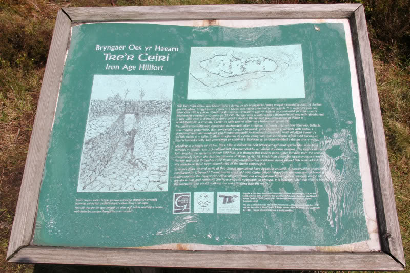
The walls of the Iron Age fort are still really high. It is thought that this fort was constructed in 100BC.
Hillfort walls:

The fort skirts right round the mountain, with numerous circular rooms, doors, etc.
Impressive fort wall:

I thought it interesting to see a door lintel being used in something so old. However, that got me thinking of seeing them in temples in Egypt which are considerably older.
Hillfort door:

Looking back to Yr Eifl and Yr Eifl North Top from Tre'r Ceiri:

View from summit of Tre'r Ceiri:

I got a great view across to Gyrn Ddu from Tre'r Ceiri. I could see the boulderfield summit and the 470m top that I visited.
Gyrn Ddu from Tre'r Ceiri:

From the summit, I could see that the cloud was still quite low in Snowdonia. A good decision to head West.
Looking down to Llanaelhaearn:

Rocks forming part of fort wall:

I descended via a waymarked path. To see the fort at its best, forget the waymarked path. The path from Yr Eifl gives much better views of the fort.
Looking back to Tre'r Ceiri:

As I skirted back round Yr Eifl, I took a short diversion out to Caergribin.
Approaching Caergribin:

View from Caergribin:

I then continued to skirt round Yr Eifl to get back to the car at Mount Pleasant.
Yr Eifl:

Lleyn Peninsula:

Trwyn y Gorlech and Yr Eifl North Top:

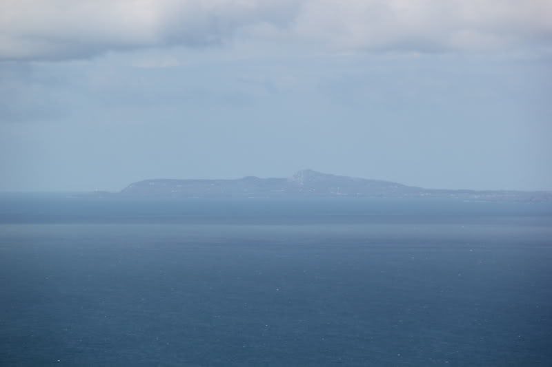
I could make out Holyhead Mountain and Holy Island in the distance. It hardly seemed like almost a week had past since I ascended this other great wee hill.
Holyhead Mountain or Holy Island (zoom):
Descending to Mount Pleasant car park:

Yr Eifl is a superb hill. Combined with Tre'r Ceiri it is quite outstanding. In some ways it reminded me of Bennachie back home, but even better! These were my final hills in this trip to Wales.
Great Orme and Holyhead Mountain were superb small hills to start the week.
The traverse of the Carneddau was a long fantastic day.
Moel-y-Gest above Porthmadog was a good wee hill.
The geology of Glyder Fawr and Glyder Fach was incredible.
Several of the Lleyn Peninsula Marilyns were also good with Yr Eifl superb!
The weather wasn't as good as it could have been – no ascent of Tryfan or Crib Goch, which can both wait for a future visit. But I'm not complaining, as there are lots of other great hills in North Wales.
In the past week I have ascended 9 Furths (Welsh 3000ft hills), 15 Marilyns, 12 Hewitts and a HuMP as well as the outstanding unclassified hill Tre'r Ceiri. Not to mention Ingleborough and Simon Fell en-route to Wales. No wonder my feet ache