
The MWIS NW Highlands forecast for today suggested, "Rain all day". However the MetOffice forecast suggested no rain to the East. I therefore set out to ascend Beinn Mhealaich and Beinn Dubhain near Helmsdale.
On pondering over the map, it was initially my intention to ascend Beinn Mhealaich from Culgower, as the OS map shows a footpath ascending from Culgower to a height of 460m. However, on reviewing a trip report by Squiz on the Scottish Hills website, Squiz advises of deep heather and that the path from Culgower is non-existent. I therefore opted to ascend Beinn Mhealaich from the high-point of the Glen Loth road instead.
The Glen Loth road must be one of the only public roads in Scotland that has as much grass as tarmac.
Hill: Beinn Mhealaich
Date: Thursday 21st May 2015
Company: Just myself
Distance: 6.5km, Ascent: 305m
Time: 1Hr 55Mins
Click here to see a map of the route undertaken
From the road high-point, I made my way towards the 377m hill which according to the Database of British Hills is called A'Chasg. From the outset of the walk it was very wet underfoot.
Heading for A'Chasg from Glen Loth road high-point:

I followed a track as far as the summit of A'Chasg. Beyond A'Chasg, it was just a case of head towards Beinn Mhealaich while trying to avoid as much bog as possible.
Looking towards Beinn Mhealaich from cairn atop A'Chasg:

Beinn Mhealaich:

Ascending Beinn Mhealaich:

Morven and Scaraben remained capped in cloud throughout the walk. However, the summits of Maiden Pap and Smean were below the cloud as was Beinn Mhealaich.
Smean and Maiden Pap (zoom):

On reaching the summit I took some photos and then headed back towards the car. No hanging around today.
At the summit of Beinn Mhealaich:

Beach North of Brora (zoom):

During the return, I decided to take a more direct route back to the car. This was a mistake as it turned out to be twice as boggy as my inbound route. By the time I got back to the car my boots were full of water.
Looking across to Beinn Dhorain:

On reaching the car, I drove further along the Glen Loth road to reach the A897. I initially parked at Baile an Or for my ascent of Beinn Dubhain. However on looking at the map I could see a 'Cup and Ring-marked Stone' marked on the slopes of Beinn Dubhain. I therefore drove further along the A897 for a more direct ascent via the Cup and Ring-marked stone.
Hill: Beinn Dubhain
Date: Thursday 21st May 2015
Company: Just myself
Distance: 4.8km, Ascent: 395m
Time: 1Hr 30Mins
Click here to see a map of the route undertaken
The ascent of Beinn Dubhain was much more pleasant than that of Beinn Mhealaich. The ground was mostly dry.
Looking back to A897 and River Helmsdale:

Strath Ullie:

Looking towards Beinn Dubhain:

I used Viewranger to find the Cup and Ring-marked stone. The stone was much smaller than I had expected.
Cup and Ring-marked Stone:

From the stone, I made my way up onto the ridge via a mix of short heather and burnt heather.
Ascending Beinn Dubhain:

During the ascent of Beinn Dubhain the cloud started lifting. I could now see Ben Griam Mor and Ben Griam Beg and also the Morven hills.
Ben Griam Mor and Ben Griam Beg:

I was half-tempted to head out to Creag Scalabsdale after Beinn Dubhain but decided to leave it for another day as it is easier to ascend it from near Torrish.
Morven, Creag Scalabsdale, Smean and Scaraben:

After visiting the North top, I continued on to the summit.
Beinn Dubhain from North top:

At the summit of Beinn Dubhain:

I decided to descend directly from the summit instead of returning via the North top. The descent was really good. During the descent, I picked up an excellent track leading down to Duible.
Descent from Beinn Dubhain:

Descent to Duible:

On reaching the car, it was still only 13:20 so I decided to ascend one more hill en-route to my accommodation in Dornoch. I made my way towards Lairg for an ascent of Meall a' Chaise.
I parked a short distance from Achnaluachrach at the start of the track leading towards the hill.
Hill: Meall a' Chaise
Date: Thursday 21st May 2015
Company: Just myself
Distance: 8.1km, Ascent: 185m
Time: 1Hr 55Mins
Click here to see a map of the route undertaken
I followed the excellent track for just over 1km until it veered off in the wrong direction.
Track near Achnaluachrach:

Looking back along track towards Achnaluachrach:

I had expected this hill to be wet underfoot. It was however much worse than expected. This was one of the wettest ascents I've ever undertaken.
2km of bog to the summit (and back):

As my feet were already wet from earlier in the day, I just ploughed through the bog.
Looking towards the summit of Meall a' Chaise:

Looking towards the Morven hills (zoom):

Looking back across flat boggy terrain:

I eventually reached the summit of Meall a' Chaise which is marked by a stone sitting on the grass. The trig point circa 300m away is 4m lower. I would normally have visited a nearby trig point but I was already scunnered with the wet terrain plus there were large dark clouds approaching. I therefore continued back towards the car, ignoring the trig point.
At the summit of Meall a' Chaise:

Morven hills (zoom):

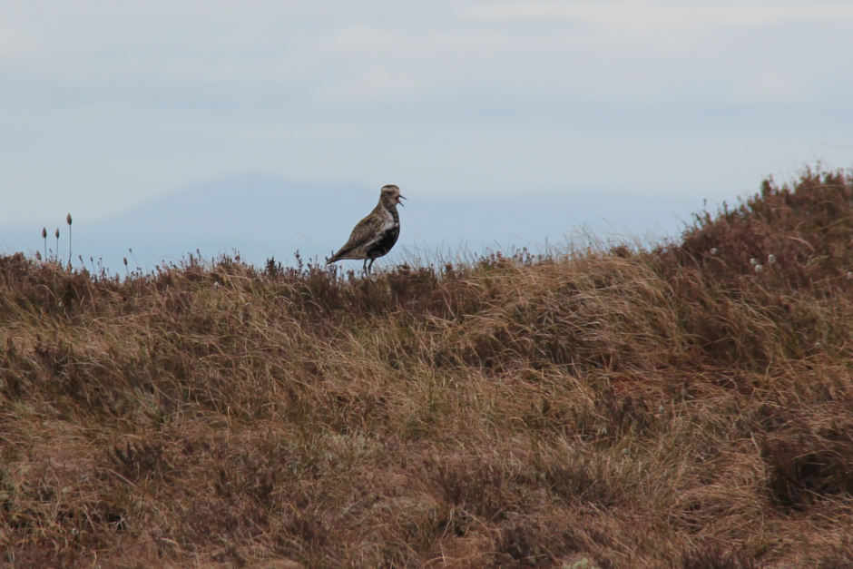
During the walk out, a Golden Plover followed me for quite some distance. I guess it was leading me away from its nest.
Golden Plover:
I also spotted three Buzzards not to mention Skylark and Lapwing.
A Buzzard:

The rain started a couple of minutes after reaching the car. Good timing