
On passing Scaladal, as per on two previous trips to Lewis/Harris, I drove down to the shore on the off-chance I could find a friendly fisherman willing to take me across to Eilean Shiophort (and back). Would this be third time lucky?
I had the advantage this time of being nice and early i.e. before fishermen had already headed out in their boats. I spoke with a fisherman who confirmed, "Yes". I would have to wait circa twenty minutes before leaving and I would be picked up around midday i.e. I would have approximately three hours on the island.
As a thank you, I offered 20 "beer tokens" which were gratefully accepted. I now had a real wee adventure ahead.
Hill: Eilean Shiophort
Date: Friday 15th April 2016
Company: Just myself
Distance: 1.8km, Ascent: 217m
Time: 1Hr 15Mins
Before setting off, I was provided with a lifejacket. From Scaladal, we set off walking a few hundred metres round the shore to reach a small boat which was anchored just offshore.
Our boat:

After pulling the boat ashore, we climbed aboard and were soon making way across at speed to Eilean Shiophort. For such a small boat it could really shift
Aboard the boat heading for Eilean Shiophort:

Looking back towards Scaladal:

Getting landed on the island was the most difficult part of this wee adventure. There is no jetty or landing area, so it is a case of step/jump out of the boat onto slippery seaweed-covered rocks.
If doing this trip, a pair of wellies could be useful for this part. Thanks to some excellent maneouvering by the boatman, I managed to get ashore with dry feet. I was asked to keep hold of my lifejacket to make it easier for them to spot me later in the day when picking me up. After sticking the lifejacket into my rucksack, I began my ascent of Eilean Shiophort.
Ashore on Eilean Shiophort:

Click here to see a map of the route undertaken
Despite having circa three hours available, I set off at a good pace as I did not know how long it would take to reach the summit. The boatman thought it would take about an hour to reach the top.
Looking back towards Scaladal and An Cliseam during initial ascent:

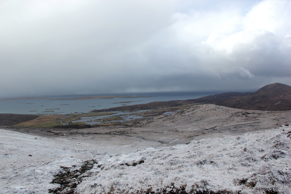
Loch Seaforth:

During the ascent, views were fairly limited so I did not take many photos.
Looking across to An Cliseam:

Loch Seaforth:

I reached the summit 24 minutes after setting off
View from the summit of Eilean Shiophort:

View from the summit of Eilean Shiophort:

Loch Seaforth:

It was nice to get my first good view of Caiteseal, in Pairc. Caiteseal is allegedly the remotest/hardest hill in Scotland to ascend if not using a boat. It involves considerable distance and many ups and downs to get there on foot. This one is still on the to do list.
Looking across to Pairc and the very remote Caiteseal:

Looking North along Loch Seaforth:

As I made my way down the hill, the cloud began to dissipate to provide some lovely blue sky. Why could this not have happened while I was at the top
Looking across to An Cliseam during descent:

I took my time during the descent as there was no hurry.
I got back to the shore at 10:00 but now had to wait until midday which turned out to be 12:30. I pottered about the shore for two and a half hours. While pottering about, I found a good place to step onto the boat. However within 30 minutes, this was two feet underwater. The tide comes in fairly quickly here.
Tricky landing:

Looking back to Eilean Shiophort from the shore:

Good views from Eilean Shiophort back towards Scaladal:

While checking out the shore, I found a small wire trap built into the hillside which I assume was a rat trap. It was closed and empty.
Lifejacket back on, waiting to be picked up:

Heading back from Eilean Shiophort to Scaladal:

I managed to get back onto the boat again with dry feet and we were back in Scaladal just five minutes later. It is a really short crossing!
On reaching Scaladal, I handed back my lifejacket and thanked the fisherman for taking me across
It was only lunchtime, so there was still time for an afternoon adventure. I therefore drove round to South Harris for an ascent of something there. En-route, I stopped at Tarbert to grab something for lunch.
On passing Luskentyre, I stopped briefly to take some photos. It had been my intention to camp either at Luskentyre or at the summit of Beinn Dhubh that evening. Due to inclement weather, this will have to wait for a future trip.
Luskentyre:

On arriving at Leverburgh, I visited the Am Bothan hostel and booked in for the night. I then had a look at the map to work out a route for an ascent of Roineabhal.
Hill: Roineabhal
Date: Friday 15th April 2016
Company: Just myself
Distance: 6.4km, Ascent: 460m
Time: 2Hrs 20Mins
My route to ascend Roineabhal was definitely not the quickest or shortest route, however, I liked the look of ascending the Beinn Tharsuinn ridge. I therefore parked just off the road next to Loch Moracha.
Click here to see a map of the route undertaken
On setting off, there was beautiful blue sky looking towards Roineabhal. The same could not be said for what was approaching from behind. The ascent of Beinn Tharsuinn was good. A nice, wide, easy ridge.
Beinn Tharsuinn ridge:

As well as cloud, I could see heather-burning taking place below Greabhal.
Looking across Loch Steisebhat to Leverburgh:

Looking back to Loch Moracha:

As I gained height, the summit of Roineabhal came into view. It was completely devoid of snow.
Ascending Beinn Tharsuinn, Roinebhal in distance:

Heather burning below Greabhal:

Views to the south towards the Uists and Pabbay were nice.
Leverburgh:

Bhoiseabhal and Roineabhal:

... and then the storm hit. The weather went from blue sky to heavy snow and hail in what seemed like an instant. Within fifteen minutes, the hills were transformed from green to white.
Roinebhal transformed after fifteen minutes of heavy snow:

Looking back to Leverburgh:
After the fifteen minutes of heavy snow, it was back to blue sky.
The heavy snowstorm now crossing over to the Uists:

Ascent towards the summit of Roineabhal:

The upper section of Roineabhal is rocky but it is possible to pick lines through the rocks avoiding all difficulties.
Ascent towards the summit of Roineabhal:

After visiting a large viewpoint cairn, I made my way across to the summit shelter and trig point.
Approaching the large stone shelter at the summit of Roineabhal:

At the summit of Roineabhal:

It was nice to look down to Rodal, a place I had not visited previously but would later in the day.
Looking down towards Rodal and Renish Point:

Instead of descending via the Beinn Tharsuinn ridge, I opted to descend the coire next to it. This would lead me down to a small concrete hut at its base.
View during descent:

View during descent:

Small hut:

There is a very distinctive band off rock on the side of Beinn Tharsuinn. On reaching the road, I walked a couple of hundred metres along it back to the car.
A great day spent on two Harris hills. Well-chuffed to have visited Eilean Shiophort.