
Hills: Ettrick Pen and Hopetoun Craig
Date: Friday 1st February 2013
Company: Just myself
Distance: 9.1km, Ascent: 475m
Time: 2Hrs 55Mins
In October 2009, I set out to walk the Ettrick horseshoe. Due to poor weather, and lack of views, I abandoned the horseshoe having ascended only six of the eight New Donalds. I finally got round to ascending the remaining two hills today, over three years later.
I was in two minds today whether to start the walk from Bodesbeck or Potburn. Given the weather was not great, I opted for the shorter approach from Potburn. The downside to this plan was an additional 50+ miles of driving.
When I last visited Dumfries and Galloway, in September 2012, I was surprised at the number of potholes on the roads. It is now worse - huge deep potholes everywhere. The local Council should get their backsides kicked for the state of the roads down here!
I parked at the road end.
Click here to see a map of the route undertaken
From the road end, I set off towards Potburn and Over Phawhope.
Start of track at road end:

Potburn:

A short distance beyond Potburn, a really small lamb was making a lot of noise. When I shouted “Bhuna”, it ran off
A wee lamb:

I always enjoy a walk that involves a bothy visit. Today I visited Over Phawhope bothy. Given the proximity of this bothy to the road, I wrongly assumed that it would be basic and probably a bit of a wreck. I was pleasantly surprised to find that it is a really nice bothy.
Approaching Over Phawhope bothy:

Over Phawhope bothy:
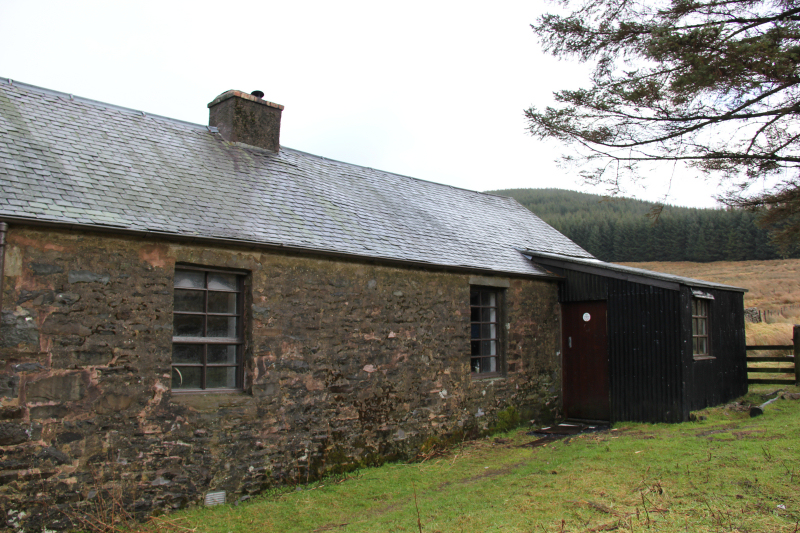
Over Phawhope bothy:

I spent around five minutes inside the bothy having a look around and signing the bothy book.
Main room inside the bothy:

Main raised platform sleeping area:

From Over Phawhope, I decided to head for Ettrick Pen first. I followed the good track to its end and then followed a faint path heading up Ettrick Pen.
Track from Over Phawhope towards Ettrick Pen:

Track towards Ettrick Pen:

It was disappointing to end up heading into the clag – a common theme for so many of my walks in this area
Looking back towards Over Phawhope during ascent:

Not much snow left on the hills in this area.
Into the clag:

On reaching the summit, I continued on following the fence towards Hopetoun Craig.
Large cairn at the summit of Ettrick Pen:

As I made my way down to the col, I saw what I thought was a small mouse run across the track in front of me. I managed to find it again in the grass, it wasn’t a mouse, it was a shrew. In the time it took to switch on the camera and for it to focus, the shrew was gone.
Looking towards Hopetoun Craig:

Looking back to Ettrick Pen:

It didn’t take long to reach the summit of Hopetoun Craig. From the summit, I continued a short distance along the ridge and then made my way over to a large well-built cairn a short distance below the summit.
Looking back towards Ettrick Pen from the summit of Hopetoun Craig:

Large cairn a short distance below the summit of Hopetoun Craig:

I then made my way towards a wide break in the trees, where I descended a scree gully back down to the track.
Descending a scree gully:

Looking back up the scree gully:

Once on the track, it was an easy plod back out to the car.
Track leading back towards Over Phawhope:

I got back to the car just after lunchtime. I had a quick look at the map to find a nearby Sub2000ft Marilyn to ascend. Cacra Hill seemed to fit the bill nicely.
For the ascent of Cacra Hill, I parked beside the start of the track signposted to West Deloraine.
Hills: Cacra Hill
Date: Friday 1st February 2013
Company: Just myself
Distance: 3.6km, Ascent: 250m
Time: 1Hr 05Mins
Click here to see a map of the route undertaken
Start of track towards Cacra Hill (Right of Way to West Deloraine):

I followed the track until past a gate and past an area of waist high tussocks and then took to the hillside.
Cacra Hill:

The ascent was straight-forward but reasonably steep.
Ascending Cacra Hill:

Looking across to Tushielaw:

Ettrick Water:

On reaching the summit area, I wasn’t sure which bump was the summit.
Looking towards the summit of Cacra Hill:

My GPS confirmed that the stone shown in the next photo is the summit.
Summit of Cacra Hill:

I returned roughly the same way as my ascent.
The weather forecast for tomorrow is much better. Hopefully it will be correct